If you’ve ever wondered what GIS is, you are not alone. GIS, or Geographic Information System, is a powerful technology that allows professionals to capture, store, analyze, and visualize geographic data. From urban planning to construction, GIS plays a crucial role in helping professionals make informed decisions based on location-based insights. In the construction and infrastructure industry, GIS is increasingly combined with BIM (Building Information Modeling) to enhance project accuracy and efficiency. This article explores the core concepts of GIS, its applications, and how it works alongside services like laser scanning to BIM modelling services to deliver real-world results.
Table of Contents
How GIS works: Core components and processes
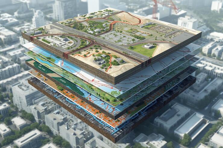
Understanding how GIS works is essential for appreciating its impact on construction, urban planning, and infrastructure projects. At its core, GIS combines geographic data, computational tools, and analytical methods to transform raw information into actionable insights. By capturing, organizing, and interpreting spatial data, GIS allows professionals to identify patterns, assess risks, and make informed decisions. In practice, this involves multiple processes ranging from data collection to visualization, each of which contributes to a more accurate and efficient representation of the real world. The following sections break down these core components and show how they work together to create a complete GIS workflow.
Geospatial data collection
At the heart of any GIS is data. Collecting accurate geospatial data is essential for creating reliable maps and models. Techniques include satellite imagery, aerial photography, and ground surveys. In modern construction projects, handheld laser scanning services are often used to capture highly detailed spatial information, which can then be integrated into GIS for precise analysis and planning.
Data storage and management
Once data is collected, it must be organized and stored efficiently. GIS platforms use databases to manage both spatial (maps, coordinates) and attribute (descriptive) data. Proper management ensures that large-scale projects, such as urban developments or infrastructure networks, can be monitored and updated in real-time.
Spatial analysis and modeling
GIS allows users to analyze spatial relationships and patterns. For example, planners can determine optimal locations for utilities, assess flood risks, or evaluate traffic patterns. Integrating these insights with 3D BIM modeling services enables engineers to create realistic 3D models that reflect actual site conditions and support better decision-making.
Visualization and 3D representation
Visualization is one of GIS’s most valuable features. Interactive maps, heatmaps, and 3D models help stakeholders understand complex data. By combining GIS with MEP BIM drafting services, designers can overlay mechanical, electrical, and plumbing systems on geographic models, ensuring designs are both functional and location-aware.
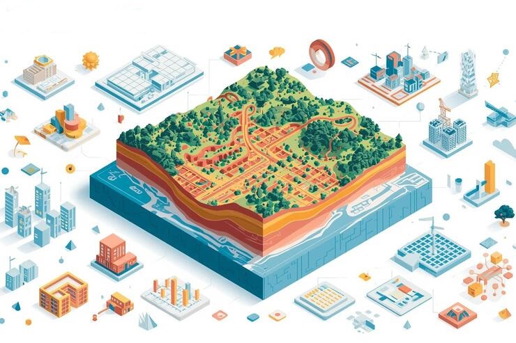
Types of GIS data
- Vector data: Vector data represents features such as points, lines, and polygons. It is commonly used for plotting buildings, roads, and utility lines on a map.
- Raster data: Raster data is composed of pixels and is typically used for satellite imagery, elevation models, or environmental mapping.
- Point cloud data: Point clouds are dense collections of 3D points captured by scanning technologies. Services like 3D BIM coordination often utilize point cloud data to align detailed building models with real-world site measurements.
Key applications of GIS in construction and infrastructure
GIS offers a wide range of practical applications that go beyond simple mapping. In the construction and infrastructure industry, it enables professionals to analyze spatial data to make better planning, design, and operational decisions. By integrating geographic information with project requirements, teams can visualize potential challenges, optimize resource allocation, and improve overall project efficiency. The following examples highlight some of the most common and impactful ways GIS is applied in real-world construction and infrastructure projects.
Urban planning and land development
GIS helps urban planners visualize land use patterns, identify suitable sites for development, and predict environmental impacts. By integrating with BIM for field layout services, planners can translate GIS insights directly into actionable construction layouts in the field.
Utility mapping and infrastructure management
Managing utilities such as water, electricity, and sewage networks is more efficient with GIS. Combining GIS with MEP BIM drafting services allows engineers to model these systems accurately and detect potential clashes before construction begins.
Construction site analysis
From terrain modeling to site accessibility, GIS provides the tools to analyze construction sites thoroughly. This reduces errors, prevents delays, and improves safety planning.
Transportation and roadway design
GIS aids in mapping traffic patterns, planning new road networks, and assessing environmental impacts. Integrated with BIM models, these analyses create more efficient and sustainable transportation solutions.
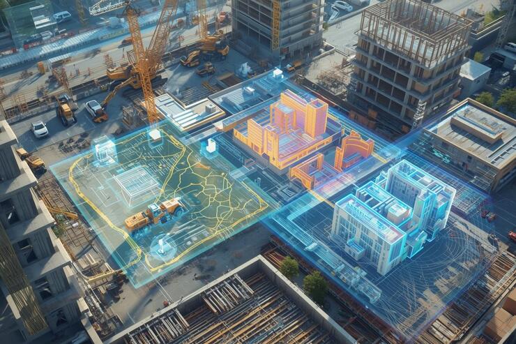
GIS vs BIM: Understanding the difference
While GIS focuses on geospatial data, BIM centers on detailed building models. Together, they create a holistic view of projects by combining location intelligence with precise building information. Using 3D BIM modeling services in California and 3D BIM coordination, engineers can synchronize models with real-world GIS data, improving coordination and reducing project risk.
Integrating GIS with BIM: Benefits for construction projects
- Improved accuracy through laser scanning: Using technologies like handheld laser scanning services and laser scan to BIM modelling services, GIS data can be captured with high precision and integrated into BIM models. This ensures that site models are accurate and reliable.
- Better coordination and clash detection: Integration enables teams to detect conflicts between systems, such as structural and MEP components, early. Coordination services like 3D BIM coordination in San Diego help align multiple disciplines with GIS data for streamlined project delivery.
- Enhanced scheduling and project management: GIS data supports construction scheduling and sequencing by providing spatial context to tasks. For example, BIM to field layout services allow teams to translate digital models directly to the construction site, ensuring accurate execution.
- Data-driven decision making: GIS allows decision-makers to visualize and analyze complex datasets, improving project outcomes. When combined with BIM insights, every decision from site planning to material procurement becomes more informed.
Real-world examples of GIS and BIM integration
- Large-scale urban developments where GIS maps determine building placement, and BIM models guide construction.
- Infrastructure projects where point cloud data from laser scan to BIM modelling services ensures alignment between designs and reality.
- Industrial sites use MEP BIM drafting services and GIS to manage underground utilities efficiently.
These examples highlight the value of integrating GIS into modern construction workflows.
Why GIS matters for modern construction companies?
GIS is no longer simply a mapping tool. It is a strategic asset that helps construction firms minimize risk, reduce costs, and optimize designs. When paired with services such as 3D BIM modeling services, handheld laser scanning services, and BIM to field layout services, it becomes a cornerstone of efficient, data-driven construction.
Conclusion
In summary, GIS goes far beyond simple mapping. It is a comprehensive system for capturing, organizing, analyzing, and visualizing geographic information. GIS provides valuable insights that help professionals make data-driven decisions, optimize project planning, and improve overall efficiency. By integrating spatial data with analytical tools, organizations can better understand relationships, patterns, and trends in their environments. As technology continues to advance, GIS will remain an essential component for construction, urban planning, and infrastructure management, supporting smarter, more informed decisions at every stage of a project.
FAQs
What industries commonly use GIS?
GIS is widely used in construction, urban planning, transportation, utilities management, environmental monitoring, and disaster management.
How does GIS improve decision-making?
By visualizing spatial data and analyzing patterns, GIS helps professionals make informed, data-driven decisions.
Can GIS be integrated with other technologies?
Yes, GIS can be combined with BIM, CAD, IoT sensors, and remote sensing data to enhance project planning and execution.
What types of data are used in GIS?
GIS uses vector data, raster data, and point cloud data to represent geographic features and attributes.
Is GIS only for large projects?
No, GIS is scalable and can be applied to projects of any size, from small site planning to city-wide infrastructure management.
Do I need specialized software to use GIS?
Yes, GIS requires software such as ArcGIS, QGIS, or other geospatial platforms for data analysis and visualization.
How does GIS help in construction project planning?
GIS provides spatial insights, site analysis, and risk assessment, supporting accurate design, resource allocation, and scheduling.
Add a Comment